Learn How GPS Works in Five Minutes!
Get Ready to Paint a Picture in Your Mind
Think in your minds eye that you can look up into the sky and see three GPS satellites in very different parts of the heavens. Think further that you have three looooooooooooooong measuring sticks that are able to reach out from you to each of the three satellites, so that you have a way of measuring the distance to each of them.
The picture you have is an upside down tripod with you at the focal point, and with each of the three GPS satellites at the end of each stick. This, of course, is totally absurd in practice, but there is a fascinating way to do the equivalent that is practical using the speed of light as your measuring stick. If you are traveling in your car at 60 miles per hour (~90 kph), and you travel for an hour, you know the distance you have traveled is 60 miles.
The speed of light is 186,000 miles per second (300,000 km/s). That is like the speed of light going around the earth a little more than seven times in one second. If we ask how far light travels in a billionth of a second, which we call a nanosecond, it is about 30 centimeters (about one foot). So, the velocity of light is about one foot per nanosecond.
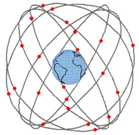
Let us suppose that the 32 GPS satellites circumnavigating the globe have atomic clocks on board each satellite, and all of them are synchronized to an accuracy of a nanosecond. They exist in six orbital planes tilted 55° to the equatorial plane, and there are four or more satellites in each orbital plane, giving good coverage of the Earth. They continually broadcast their synchronized times and positions.
Suppose, further, that you have a GPS receiver with an atomic clock in it also synchronized to GPS time to a nanosecond, and you listen to the signal from three GPS satellites in very different parts of the sky. Since all the clocks are synchronized, you can measure how long it takes for each satellite’s signal to get to you with an accuracy of a nanosecond in time, which translates to an accuracy in distance of about a foot for the three distances from you to each of the three satellites.
How to Use Your Upside-Down Tripod
To Determine Where You Are
Simultaneously, the satellites also transmit their positions in the heavens. You have effectively measured the length of the legs of an upside-down tripod at that moment in time, since the satellites also continually broadcast their positions. Hence, this allows you to calculate your position at that moment to an accuracy of about one foot since you are at the apex of the tripod.
Now Replace the Atomic Clock with a Quartz Clock
Having an atomic clock in your GPS receiver is too costly and impractical for size, power consumption, and other reasons. So, what is done in practice is to measure the delay from four or more satellites. Measuring four satellites gives you four equations with four unknowns: your longitude, latitude, altitude, and time (x, y, z, and t in mathematical terms). The solution to these four equations effectively transfers GPS atomic-clock time into your receiver without having a bulky-synchronized atomic clock.
In practice, instead of an atomic clock, GPS receivers use a frequency stable quartz-crystal-oscillator clock. Because it is stable enough over the measurement intervals needed, even though its time and clock rate may be off. Over some reasonable integration interval, the time error and rate offset of the quartz clock can be calibrated to be in agreement with GPS time. And ‘voilà,’ you effectively have an atomic clock in your receiver with your synchronized quartz clock tracking GPS time.
Practical Considerations
The satellites atomic clocks are kept synchronized by the GPS Master Control Station in Colorado Springs, Colorado, which has upload stations for the satellites around the globe. So, as long as you have four or more GPS satellites in view, your receiver can continuously calculate and know x, y, z, and t (which translates to longitude, latitude, altitude, and GPS time for your location). Also, in practice, delays for antennas, ionospheric delays, tropospheric delays, multipath reflections, receiver processing software, the quality of the quartz-clock in the receiver, and many other considerations enter into the final precision and accuracy achieved for the time and position solution from a GPS receiver. A military receiver can now achieve sub-meter accuracies in real-time. A few meters of accuracy are now obtained for civilian receivers in real-time.
GPS Applications have Grown Exponentially
The applications for the use of GPS have grown exponentially over the last three decades, and now the civilian applications vastly outnumber the military even though it is a military system, and their usage is enormous. In the beginning, the military applications were paramount and significantly outnumbered the civilian applications. GPS receivers were very expensive. The first GPS timing receivers used at the United States Naval Observatory (USNO) cost over $100,000. With the large number of civilian applications, that has changed dramatically. Most people have a GPS receiver in their cell phones.
In the 1980s, while I was working at the National Bureau of Standards, in Boulder, CO, we built some special GPS timing receivers to be used in what we called the GPS “common-view” mode. If I have clock A, say in Boulder, and clock B, say in Paris, France, at the BIPM (International Bureau of Weights and Measures), where international time is generated, then we measure at the same moment the same GPS satellite’s delay-corrected arrival time (G) at both locations; that is you measure A – G and B – G. We calculate (A – G) – (B – G) = A – B. Since we are measuring the same clock, G, this difference gives us the time difference between the clock in Boulder and the clock in Paris. The precision and accuracy of this technique is of the order of a nanosecond. When developed, it became the principal means of communicating the times of some 500+ atomic clocks from around the world to the BIPM for determining International Atomic Time (TAI) and UTC (Universal Time Coordinated) – the official time for the world.
The Civil Applications are Growing Rapidly
In many of the civilian applications of GPS, it is used in what is called the differential mode. This allows one to cancel or reduce significantly a lot of the systematic delay errors. In this mode, centimeter accuracies are obtained. For example, this mode is used in surveying, road construction, farming, earthquake monitoring, etc. This requires two GPS receivers: one at a known and fixed position and which communicates its information to the other receiver, which in turn observes the difference between the two readings — bringing about the cancellation of most of the systematic errors that otherwise would be present.
Downside of GPS
The GPS signal as received is so tiny that it can easily be jammed. This is a major problem for the military and gives great vulnerability; this happened in the Iraq war. Another problem is that four satellites are needed for a complete solution; if your GPS receiver is in an urban or a real canyon so that less than four satellites can be seen then a full solution cannot be obtained, and other techniques need to be utilized to get around this problem. Also, the signal is not received inside buildings and underground. There is also no back up system for GPS currently available. In 2005 we published results for a possible back up technique. Such may yet come into place because of the GPS vulnerability problem.
A More Comprehensive Article on How GPS Works
Hewlett Packard asked me to write a general layman’s tutorial on timekeeping and GPS. I asked Professor Neil Ashby, who did the relativity calculations for GPS, and Dr. Cliff Hodge, a space-clock expert, to help me with it. With permission from MicroSemi, who now owns the copyright, I have it on our web site, and is an 88 page booklet called The Science of Timekeeping. Chapter 20 of my book gives more details as well. What a great impact GPS has had on the world. Because of vulnerability questions, it is wise to plan alternatives, and to not totally depend on it.
David W. Allan